• Topic navigation
  • Content
  • Footer links
Start Toggle navigation
  • Map
  • Find an employee
  • KUnet
  • Dansk
  • Education at UCPH
    • Bachelor's programmes
    • Master's programmes
    • Study abroad
    • PhD programmes
    • Continuing Education
    • Course search
  • Research
    • Researchers and publications
    • Research centres
  • News
    • Rector:” We want to bolster Denmark for the age of AI” Rector:” We want to bolster Denmark for the age of AI”
      2025.10.31
    • 97 percent of women in Denmark experience symptoms during menopause 97 percent of women in Denmark experience symptoms during menopause
      2025.10.30
    • Tourists flock to the Faroe Islands – but meet resistance from locals Tourists flock to the Faroe Islands – but meet resistance from locals
      2025.10.30
    • All news
    • Press service
  • Innovation
  • Employment
    • Job portal
    • Career for young researchers
    • For international employees
  • About UCPH
    • Strategy
    • Facts and figures
    • Profile and history
    • Collaboration
    • Organisation
    • Faculties
    • Departments
    • Museums and attractions
    • Libraries
    • Alumni
    • Contact
Københavns Universitet
Niels Bohr Institute

Niels Bohr Institute

  • The institute
  • Education
  • Research
  • Staff
  • Library
  • Jobs
  • Contact us
  • Niels Bohr Institute
  • Research news
  • News 2017
  • Satellite photos reveal gigantic outburst floods
  • The spy satellite

The spy satellite


 The spy satellite
The NBI-researchers relied on a number of different satellite photographs when describing the four gigantic outburst floods from Lake Catalina taking place between 1966 and 2012.
Read more >>
 

The 1966-photographs were taken by the American spy-satellite Corona KH 4-A. This satellite-type – in operation from August of 1963-October of 1969 - was part of the Corona program, controlled by the  CIA. The first Corona-satellite was launched in 1959, the last (KH 4-B) stopped taking pictures in 1972. The purpose of the Corona-program was to provide surveillance-photographs from in particular USSR and The People’s Republic of China, but from certain other countries and regions as well.

These photographs were de-classified in 1995 and have since been of great use in various fields of non-military research. The Corona-satellites orbited at altitudes between 120-160 kilometer above the surface of the Earth. The pictures were shot with custom made cameras using a 70 millimeter film from Kodak-Eastman.
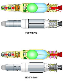
Recreated pictures of Corona KH 4-A from the site and top

Corona KH 4-A satellite. Image: Guiseppe De Chiara 1968. The image is reproduced under Creative Commons.

When  a mission was completed and it was time to retrieve the film, the so-called film bucket – a section of the satellite – was released. The film bucket, which had a heat protection shield, ejected a parachute when it reached a hight of approximately 18 kilometer above the surface of the Earth. Some film buckets were caught while still airborne by military planes equipped with a ’claw’ – in other cases the film bucket landed in the ocean where a vessel from the US Marine would pick it up.

Niels Bohr Institute
University of Copenhagen
Jagtvej 155 A, 2200 Copenhagen N.
Contact:
Henrik Larsen
henrik.larsen@sciencewriter.dk

University of Copenhagen

  • Management
  • Administration
  • Faculties
  • Departments
  • Research centres
  • Animal hospitals
  • School of Dentistry
  • Libraries
  • Museums and attractions

Contact

  • Map
  • Find an employee
  • Contact UCPH

Services

  • Press and media service
  • Merchandise
  • IT-support
  • For suppliers

For students and employees

  • KUnet

Job and career

  • Job portal
  • Jobs for students
  • Alumni

Emergencies

  • Emergency response

Web

  • Cookies and privacy policy
  • Accessibility statement
  • Information security

Connect with UCPH