Conceptual model can explain how thunderstorm clouds bunch together
Understanding how the weather and climate change is one of the most important challenges in science today. A new theoretical study from associate professor, Jan Härter, at the Niels Bohr Institute, University of Copenhagen, presents a new mechanism for the self-aggregation of storm clouds, a phenomenon, by which storm clouds bunch together in dense clusters. The researcher used methods from complexity science, and applied them to formerly established research in meteorology on the behavior of thunderstorm clouds. The study is now published in Geophysical Research Letters.

The life and death of a storm cloud
When the sun warms up the surface of the ocean, warm, humid air rises from the ocean surface, forming tall, columnar thunderstorm clouds, which reach heights of approximately 12 km and measure typically only a few kilometers across.
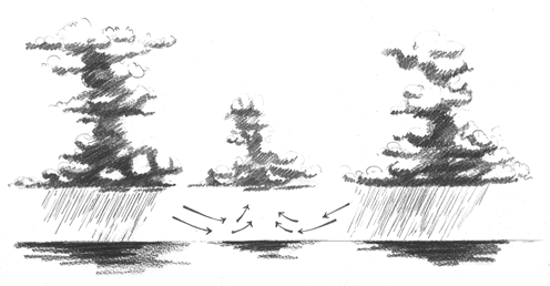
As these clouds produce rain, some of it evaporates and cools the local area under the cloud. By this, the initial circulation of air, forming the cloud, is shut down and the cloud dissipates. If it were this simple, this should be the end of the thunderstorm cloud.
However, the dense air below the cloud needs to equilibrate with less dense air surrounding it: “Cold air is denser, and it spreads away from the cloud. Gust fronts are formed which can collide with gust fronts from other clouds.
As a consequence the air rises up, and new clouds are produced. This means that areas where sufficiently many clouds are, are more likely to set off additional clouds", Jan Härter explains (Illustration 1).
“Areas with fewer clouds exhibit further reduction of clouds. As energy needs to enter the system, and since energy comes from the sunlight, there is a limit to how big the cloud lumps can grow – so we put a constraint into our model. The result is that cloud clusters form, with cloud-free regions in between. This is also seen in observations for the tropical ocean.”
Combining theory with real world phenomena
Building models is purely theoretical, but still manages to explain a phenomenon. “It is a theoretical argument, a suggestion for a mechanism that can now be tested. Clustering of thunderstorm clouds has been observed in the real world, but still lacks a scientific explanation.
If we contrast two extreme cases, where one cloud is created, it ends up shutting itself down. Then statistical mechanics says no convective self aggregation will take place. Comparing this to another model where two clouds create another one, aggregation can take place. That’s basically what the theoretical model can do”.
Jan Härter goes on: “This type of self organization is hugely interesting and can occur in a range of systems from biology to magnetism.
Preparing for the destructive force of the weather
Tropical meteorology is, due to the strong interaction of clouds with solar irradiation there, relevant for climate change. More clustering in a future climate might affect how much the ocean warms, relative to the rate seen today.
Prediction of clustering of storm clouds could affect the weather in Denmark as well, and fairly recent events in Denmark with surprise flash floods, flooded sewers and basements, and damage to infrastructure has prompted questions on the origin of such sudden floods. Deeper understanding of how clouds interact could shed new light on the occurrence of such floods.
Illustration of the conceptual model. To begin with, the humid air is evenly distributed over the surface of the sea (the blue colour). But the self aggregating mechanism means that clouds are formed and self organize into clusters of clouds of a fairly uniform size.
The white areas are cloud free. Animation: Jan Härter
Link to the scientific article >>
Topics
See also:
Contact
Jan Olaf Mirko Härter, Associate professor, Center for Models of Life, Niels Bohr Institute, University of Copenhagen Email: haerter@nbi.dk Phone: +34 6042-56282
