Research highlights
Key publications: Below you can find several recent key publications from our group. These publications deal both with the observational characterization of convective precipitation and high-resolution modeling. Full publication list here >>

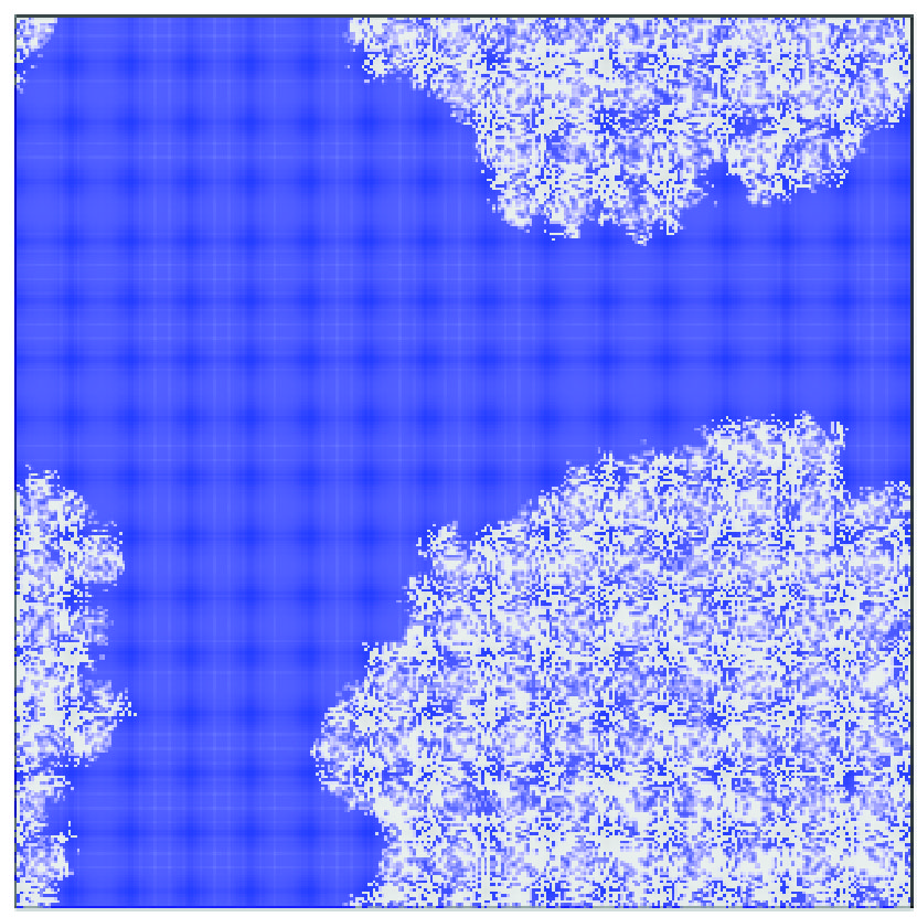
Convective self-aggregation within a simple conceptual model. White and blue regions are cloudy and non-cloudy sub-areas. |
Convective self-aggregation as a cold pool driven critical phenomenon Jan O. Haerter, Geophysical Research Letters (2019) Convective self-aggregation is when thunderstorm clouds cluster over a constant temperature surface in radiative convective equilibrium. Self-aggregation was implicated in the Madden- Julian Oscillation and hurricanes. Yet, numerical simulations succeed or fail at producing self-aggregation, depending on modeling choices. Interaction between cold pools, caused by rain evaporation, drives reorganization of boundary layer moisture and triggers new updrafts. We propose a simple model for aggregation by cold pool interaction, assuming a local number density of precipitation cells. Our model mimics global energy constraints by limiting further cell production when many cells are present. The phase diagram shows a continuous phase transition between a continuum and an aggregated state. |
|
Precipitation onset as the temporal reference in convective self-organization Jan O. Haerter, Peter Berg, Christopher Moseley, Geophys. Res. Letts, DOI: 10.1002/2017GL073342 We use idealized large-eddy simulations to explore how the horizontal scale of convection is modified during this transition in the course of a diurnal cycle. Before onset of precipitation cells with relatively constant diameter self-organize, with diameters roughly on the scale of the atmospheric boundary layer height. We find that the onset of precipitation then signals an approximately linear increase in horizontal scale with time. For our transient simulations, this scale increase progresses at a speed which is relatively insensitive to modifications in mean surface temperature, modifications in the rate at which surface temperature changes, or the initial lapse rate. We discuss possible implications for the development of extreme precipitation events. |
|
|
Convergence (blue to red) and divergence (green) of moisture for a 100 km segment (horizontal axis) of our high-resolution simulation throughout the day (vertical axis). Note the structuring of the patterns, which develops larger and more intense features later in the day.
|
Intensification of convective extremes driven by cloud-cloud interaction Christopher Moseley, Cathy Hohenegger, Peter Berg, Jan O. Haerter, Nature Geoscience (2016) 9, 748-752 We use high-resolution large eddy simulations (horizontal resolution 200 m) to simulate a flat land surface of approximately 200 km x 200 km. Several idealizations were made to focus on several core processes. The aim was to understand how clouds organize in space and how extreme precipitation is produced. We find that clouds that "erupt" in isolation are unlikely to produce extremes. It takes collision events, or "mergers", of several clouds to obtain the strongest extremes. These extremes are found to become stronger in the course of the day — remarkably even when the overall energy input into the atmosphere, i.e. solar heating, is already on the decline. |
|
Spatial (horizontal axis) and temporal scales and comparison of probability distribution functions (PDFs) for precipitation intensity. Blue (red) shades show good (poor) agreement of PDFs with the resolution highlighted by a circle.
|
Statistical precipitation bias correction of gridded model data using point measurements Jan O. Haerter, Bastian Eggert, Christopher Moseley, Claudio Piani, Peter Berg, Geophysical Research Letters (2015), 42 (6), 1919-1929 Precipitation intensity varies strongly with spatial and temporal scales. In many applications, measurements are made over a specific window of temporal and spatial resolution, e.g. 1h in time and 25 km in space in climate model simulations. In such cases, one may want to compare the statistical distribution of intensities with those measured at different resolutions, e.g. a point observation (0 km spatial resolution) made over 1h. We study here, how the two resolutions can be made compatible in a statistical sense and how to extract a rescaling of resolutions from a model. |
|
Radar image (dark patches) of precipitation intensity over Germany. Pink area shows composite regions covered by 16 radar images. Symbols "C" and "M" mark areas classified as being exposed to convective, respectively mixed, conditions of cloud.
|
Strong increase in convective precipitation in response to higher temperatures Peter Berg, Christopher Moseley, Jan O. Haerter, Nature Geoscience (2013), 6 (3) 181-185 When high-resolution radar observations are combined with temperature data, a detailed spatial characterization of the atmospheric conditions can be made. In this study we combine these data with so-called "synoptic measurements", weather type classifications recorded at weather stations by meteorologists. These classifications allowed us to distinguish convective precipitation from other types of precipitation, e.g. stratiform precipitation. This study was then able to investigate how convective precipitation intensity is modified when temperatures increase. It was the first time this was done explicitly for convection, highlighting that convective precipitation intensity increases more strongly than would be expected from thermodynamics, i.e. the equilibrium statistical mechanics relation (Clausius-Clapeyron equation). |
|
Precipitation intensity vs. surface temperature. Black/blue/red lines show overall, convective and large-scale component of precipitation, arrows highlight the possible super-C-C increase of precipitation intensity.
|
Unexpected rise in extreme precipitation caused by a shift in rain type? Jan O. Haerter & Peter Berg, Nature Geoscience (2009), 2 (6) 272-273 Generally speaking, convective precipitation is triggered when the temperature at the surface is sufficiently high. Stratiform precipitation occurs at lower temperatures and is driven by large-scale lifting processes. Furthermore, stratiform precipitation is generally weaker, this also applies to the extremes. When temperature now increases from low to high, and the two precipitation types are recorded in one big mix of data, the extremes could be perceived as increasing strongly at the intermediate range of temperatures, where both precipitation types are possible. This is one (statistical) effect, that can lead to a larger than 7%/K increase, but does not constitute a discrepancy to the Clausius-Clapeyron relation. |
