
What is convection?
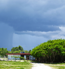
Convective precipitation observed over Cuba.
Convection is buoyancy driven
Convection is a consequence of strong heating of moist surface air. Warmer air expands and is therefore subject to buoyancy relative to the surrounding, more dense, air. This buoyancy causes rapid lifting of surface air. In contrast, stratiform cloud is often caused by cyclonic activity, where the collision of fronts causes large-scale lifting of moist air. Such lifting processes are generally slow compared to convective updrafts.
Convective precipitation is local
In general terms, the convective precipitation of a single convective updraft (see the image to the right) falls over relatively short times and covers areas of only few kilometers across. For extreme events, it is not uncommon to measure 50 mm of rain in one hour. Such strong rain can cause flash floods, local floods that arise within hours and can be devastating to human lives and infrastructure.
Convection is hard to simulate in climate models
Because of its local nature and complex dynamics, convection continues to pose basic challenges in coarse-scale models. Standard climate models have horizontal resolutions of roughly 50 km, while typical scales of convective events are far less than that, often around 1-10 km. To simulate single events, or their interaction, properly, models must have resolutions better than 1 km.
Facts on convection
| We here use "convection" as capturing both the classically studied process of Rayleigh-Bénard convection as well as atmospheric convection. The former results in a one-phase fluid, when a lower plate is heated relative to an upper, and an overturning motion is induced. Convection in the atmosphere generally includes phase changes of water, leading to rapid redistribution of heat − and mass, when precipitation falls towards the earth surface. |